ICBDA was absolutely awesome! We were pleasantly surprised to realize that our stamina had survived the 16 month break from Round Dancing & that we still loved dancing & teaching just as much and maybe even more than ever! Now we were ready for some sightseeing!!
I made generalized plans to include where to park the RV and where to start the first exploration, but didn't really have detailed decisions. Even though I had started planning our adventures for July back in February, many of the RV parking spots were already full & I was not able to get us exactly where I wanted. So the RV was parked just off of I64 in Grassy Meadows, WV - about 25 miles east of the New River Gorge National Park. We got the RV situated & immediately took off to explore. So......first stop was Sandstone Visitor's Center. Lucked out to run into a very helpful female ranger who first pointed out the Purple Vetch that the park is trying to remove from it's grounds (it is not native & spreads like wildfire killing local vegetation) & then inside to mark my map for where to go & in what order! Following her directions, we drove around the northeast edge of the park to head to the northern portion of the park.
First stop was the Glade Creek Grist Mill in Babcock State Park. It is a replica of the historical mill that originally stood nearby. It is a working mill & there is a ranger posted inside to provide some history & answer questions. They sell local products & you can actually stay in the State Park at cabins & campground. Our friendly informative Ranger had told us that it was one of the most photographed sites in West Virginia so we HAD to stop there! It is set in a lovely location & is extremely photogenic. It is there to remind folks that the local residents survived for years by making use of these local mills.
Enjoyed seeing these guys in costume taking a tour of the park. They seemed to be having a great time!
We continued north towards the Canyon Rim Visitor's Center. We bypassed the Visitor's Center itself (it was closed - it was already after 5pm) & took the Fayette Station Road Scenic drive. Here's an excerpt from the NPS explanation of this road:
Exploring Fayette Station Road is to travel back in time before the modern New River Gorge Bridge was built in 1977. This one hundred year-old road of hairpin turns winds down to the bottom of the gorge, across a narrow bridge, and up the other side. Visible along the way are vistas of the river and bridges, a hardwood forest, and remnants of the New River Gorge communities that once teemed with activity.
In 1873 the C&O Railway opened this rugged wilderness and carried coal out of the gorge to ports in Virginia and cities in the Midwest. By 1905, thirteen towns sprang up between Fayette Station Road and Thurmond 15 miles upstream, about one per mile. Between the 1870s and the 1950s, West Virginia coal contributed significantly to the industrialization of the United States as it fed the nation's trains, factories, and fleets.
At river level, Fayette Station Road runs directly through remnants of the townsites of Fayette and South Fayette. The establishment, growth, and ultimate demise of these two towns represent the general life cycle of a town in the gorge. A landowner or mining company opened a coal mine and built company-owned houses and a store, creating a company town. Decades later, when the coal seam was exhausted or the mine closed because of changes in the marketplace, people moved away and these towns were ultimately deserted.
Today, the New River Gorge is known for its outstanding natural and scenic beauty. The many remains of the once vibrant towns, mines, and homes that filled the gorge are now mostly hidden beneath layers of native vegetation. Along Fayette Station Road, however, some remnants of the area's coal mining and railroad heritage prevail.
The weather was fine & the views of the New River Gorge bridge, which was completed in Oct 1977 to replace the long winding drive on the Fayette Station Rd. The old bridge was reconstructed & it opened in 1998.
We skipped a day at the park & went on a tour of the Greenbriar Underground Nuclear Bunker, then continued on our exploration of the New River Gorge NP. We drove to the Grandview Visitor's Center & arrived in a light drizzle. We went inside & it started pouring heavy rain. We spent a lovely 20 minutes chatting with the volunteer ranger inside.
After the rain slowed a little, we took the short walk to see the "grandview" of the park. It was definitely GRAND!!
We originally intended to take the short mile or so walk to the other viewing stand, but it was looking rainy, so we took the car. Just as well, because it started pouring again. We took the short walk to the viewing stand anyway & enjoyed the view.
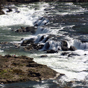
We immediately headed south & then east on I64 to the exit for Sandstone Falls. It was still drizzling a little & we saw some deer crossing the road. Here's what the NPS has to say about the area:
Sandstone Falls marks the transition zone of the New River from a broad river of large bottomlands, to a narrow mountain river roaring through a deep boulder strewn V- shaped gorge. The falls form the dramatic starting line for the New Rivers final rush trough the New River Gorge to its confluence with the Gauley River to form the Kanawha River.
Sandstone Falls from above
NPS photo/Dave Bieri
Your journey to view the falls will require some driving time, but it will take you along two of the park's most scenic roads, Route 20 from I-64 at the community of Sandstone, ten miles upstream to the town of Hinton, then downstream eight miles along River Road, the park's only scenic riverside drive. Both these routes offer several overlooks, historic sites, natural areas, trails, and river access points.
The first stop has an overlook with a faraway glimpse of the falls. Lots of trees to block the view too.
The next stop mentions an eagle's next visable in a Sycamore tree on the tip of the island. If I hadn't have read the sign, we would have missed it. First I had to figure out which was the sycamore tree!! You can just see a small black/white blob at the top of the pale trunk of that tree on the tip. The mom & dad were easily visable with my binoculars. You'll see them better as we travel to the other side of the river.
The Falls were a bit of an anticlimax, but the walk along the boardwalk was nice.
The river side Mobile home community built up on stilts was very strange to see. Very 3rd Worldish.
Stopped for a little closer view of the Eagle's nest. Still not totally close, but we could easily see the 2 adults on the nest with our binoculars. Fun to see them!
Continued the drive along the river & just couldn't resist more pictures of the Mobile home communities on the stilts. Just amazing (& junky). Anyway, really enjoyed exploring this park. Well worth the visit & can understand how it got to the National Park identification. On to the next!


No comments:
Post a Comment